
Tags
"Ahu", "Moai", Anarctica Peninsula, Antarctica, Drake Passage, Easter Island, Icebergs, Lindblad Expeditions, National Geographic, Rapa Nui, The Explorer, Ushuaia
Usually, I’m not at a loss for words.
But we have just returned from a three-week trip, first to one of the smallest, most isolated and most fascinating islands in the middle of the Pacific Ocean and then on to the most remote, virtually uninhabited and most picturesque continent on our planet, and I’m having trouble trying to capture what we experienced.
Nothing I can write will match the photos that my wife Ellen has taken and that I’ll post on this site when she has sorted through her 1600 saved pictures.
In the meantime, however, here are two iPhone photos I took and an attempt at relating some of the impact these two very different places had on me.
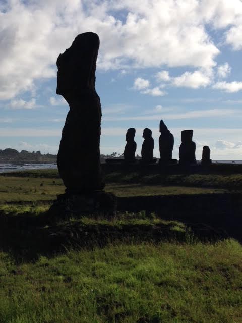
Easter Island (Rapa Nui)
Our inclusion of Easter Island was almost an after thought, a ‘tag on’ to the principal reason for this trip – a visit to Antarctica. Ellen said, “Let’s include Easter Island since it’s on the way.” (Ellen has long been ‘geographically challenged’ and didn’t know we’d have to go 2500 miles — 5,000 miles round trip – out of our way to add Easter Island to our itinerary.)
Since it was largely my desire, not Ellen’s, to go to Antarctica, I quickly agreed to her suggestion “to stop at the island with all those statues.”
And a fantastic suggestion it was.
The week prior to leaving, and knowing virtually nothing about Easter Island, I started reading The Statues that Walked: Unraveling the Mystery of Easter Island by Terry Hunt and Carl Lipo. I was fascinated.
When we finally landed (after a nine hour flight delay because of bad weather on the island — you don’t want to get to Easter Island and not be able to land), I couldn’t wait to see the Moai, the carved, stone statues.
For the next two and a half days, we crisscrossed the triangle island’s 64 square miles, seeing more than 100 of the statues, most of the 40 that have been restored to their platforms (Ahu) and many of those that have been pushed down or fallen over and remained where they fell. Plus, we spent a large part of one day wandering through the quarry where the statues were carved (and many remain in various stages of complete/incompleteness).
We were captivated.
For someone who is not particularly interested in archeological sites, I couldn’t get enough of these statues.
I wanted to know everything about them – how and why they were carved; what they represented; how they were transported; why some remained standing; why many were pushed over, or fell; why some were abandoned during the carving process; who restored them; how that restoration was accomplished. And I had so many questions about the people who carved them and who inhabited the island.
Some of these questions were answered, or at least our guides gave their answers to our questions, and we continued to read and learn about the Rapa Nui (both the name of the island and the name of the people who settled on the island) throughout our all too brief stay.
But many mysteries remain about the island, the people who settled there, and the statues.
I suspect I will now spend time learning more about Easter Island. And I look forward to reading about both the various existing theories as well as the new discoveries that hopefully will be made in the years to come.
The statues you will see in Ellen’s photos are now embedded in my mind and will remain among some of the most fascinating and intriguing images I have seen in my many years of travel.
Antarctica
I’m not sure when I first became interested in visiting/seeing/traveling to Antarctica, but it’s not a stretch to say it’s been in/on my mind for most of my adult life. And though I’ve been traveling widely and great distances since my first overseas trip (Africa in 1963), I had never found sufficient time to go to Antarctica since you need to plan your trip for the summer months there (December, January, February).
When Ellen decided to retire near the end of 2014 (I had already been retired for several years by then), she said, “Let’s go somewhere in January so I won’t have to worry about what I’m going to do in the first months of not working.”
Ah. Antarctica at last.
Since the only way to visit Antarctica is by ship (unless you are part of a research project and have access to one of the scientific ‘settlements’ on the continent), we settled on a Lindblad/National Geographic ‘expedition.’
So after the Easter Island adventure (see above), we made our way from Santiago to Buenos Aires and down to Ushuaia in late January. Loaded with the recommended layers of clothing and the seasick medications prescribed by doctors and friends, we boarded the M.S. National Geographic Explorer ship on January 29th. The ship headed out the Beagle Channel and into the (dreaded) Drake Passage. We were on our way for a ten-day, 2200 mile round trip odyssey.
The passage was “benign,” according to the crew of the Explorer, and we awoke on the morning of Jan. 31st approaching the South Shetland Islands. For the next week, we traveled along the Antarctica Peninsula, going south below the Antarctic Circle before turning back north.
The weather continued to be mostly delightful, with the coldest day just a degree or two below freezing and with clear skies for much of the time.
Each day there was a morning and an afternoon excursion off the ship. Traveling on Zodiac boats, we’d join a group of eight to ten people to explore an island or the mainland, to wander among the penguins, to hike on a glacier, or to visit one of the few remaining explorer outposts, most of which had long ago been abandoned.
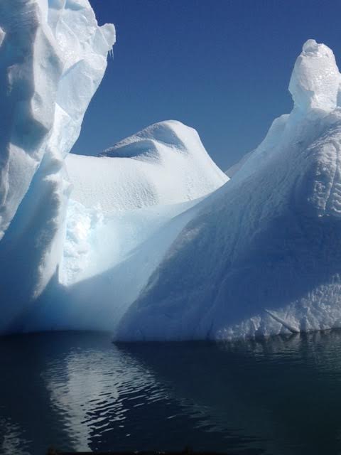
Some days we would just stay on the Zodiacs and observe the sea life (whales, birds and seals) and the icebergs. There were two kayak outings for those brave enough to take up that option.
For me, I mostly wanted to observe and experience the whiteness and silence of a world that is different from any other place I have ever been. I never tired of gazing at the ice and the icebergs, some as large as cathedrals and multistory buildings. (According to the National Ocean Service, “To be classified as an iceberg, the height of the ice must be greater than 16 feet above sea level and the thickness must be 98-164 feet and the ice must cover an area of at least 5,382 square feet.“ Only one tenth of an iceberg is above the water, hence the phrase, ‘the tip of the iceberg.’)
I could not get enough of what we were seeing.
All too soon we were headed back north, and this time the Drake Passage was anything but ‘benign.’ We spent much of 24-36 hours doing our best to stay upright and keep from losing what was in our stomachs. But the final six hours were calm and the beauty of the Beagle Channel made for a lovely end to the voyage.
Often when one has spent a great deal of time looking forward to an event, that event cannot equal the expectations one has built.
Not so Antarctica.
It far surpassed expectations.
Just wait until you see Ellen’s photographs.

Cheryl Mawo said:
What a wonderful opportunity and trip, Rick! Thanks for sharing – looking forward to Ellen’s photos.
Cheryl
Roger Nelson said:
What great power there is in the written words you have put down.
I felt like I was there with you. I can hardly wait for Ellen’s pictorial recitals.
Elizabeth said:
So awesome. While you guys were gone, I watched this documentary on Easter Island and now I’m obsessed with going. http://www.bbc.co.uk/programmes/b03srmm6. It’s available on Netflix as well for anyone who is interested. Brandt and I will pass on Antartica, I wouldn’t get on that ship for anything in the world!
Lydia said:
Amazing. I was obsessed with both of your Instagram feeds during this particular trip, and I love hearing your impressions. Unfortunately I’m sure that we won’t get to those spots until we’re retired as well, but this helped jump them up the list. xoxo
Janet miller Brown said:
You should have been an author!
Your descriptions are fascinating!
I’m so glad we will be in dc for Passover
& really look forward to more details &. photos
We felt somewhat thoroughly involved thru your photos & small heads up on your days
Absolutely amazing!
Ping said:
An ancient Chinese saying goes: ” To read ten thousand books is not as good as to travel ten thousand miles.” But I think nothing is be better than reading thousands of books and traveling thousands of miles.
Your sharing your views, pictures and thoughts as your travel experiences progressed, with modern technology, benefited many. Thank you for your report and Ellen’ special pictures.
The trouble is: “Hearing it a hundred times is not as good as seeing it once.” I wish I were there.
Richard said:
Ping – Keep those Chinese sayings coming. They resonate.
In this specific instance, perhaps hearing this once (about Antarctica & Easter Island) will result in your going to see them for yourselves.